
When we aviation buffs take a flight, we feel great satisfaction and we let out a faint smile if during check-in, we are randomly assigned a window seat instead of an aisle seat.
From this position we can get a close look at all the handling operations (apron, cleaning, catering, fuel, etc.), we listen carefully as the engines start up, the hydraulic systems, the strange noise of the PTU (which some describe as a barking dog, and others as a sawmill), we observe all the signs and the taxiway lights, watch as the flaps are extended… Some time later, as the plane progresses through the stages of take-off, we see how houses, road vehicles and roads get smaller and smaller, and we focus our gaze on the horizon in search of other planes, but all we see is clouds.
Knowing how to identify each type of cloud not only lets us anticipate changes in the weather, but also know if our flight will take place in normal conditions.
Have you ever stopped to think about how many types of clouds there are? And how clouds affect planes? Well, come with us on this journey…
Clouds are the visible effect of a series of dynamic and thermodynamic factors that take place in the atmosphere. Considering this reflection, then, the different types of clouds (or their absence) represent the real “weather”.
A cloud forms when a mass of humid air cools until it becomes saturated and subsequently condenses.So in order for a cloud to form, we need the following conditions:
- A mass of humid air
- Cooling
- Presence of condensation nuclei
In order to better study them, scientists have classified clouds in different ways, such as their appearance, type and elevation, which is the classification we will use in this article. We will thus classify clouds as high-level, mid-level and low-level.
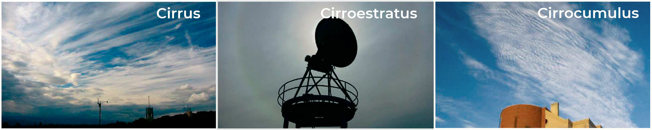
High-level clouds
The base of a high-level cloud ranges from 6,000-18,000 metres in the tropics, and 3,000-8,000 metres in the polar regions. At this altitude, the air is quite cold and dry, so these clouds consist almost exclusively of ice crystals. The different types of high-level clouds are:
Cirrus (Ci).
These clouds look like white, delicate filaments, and narrow banks and strips, and they are white and off-white. Fibrous appearance, silky glow.
When they are isolated, they are indicative of good weather, but if they are moving in sync and increasing to the north, this indicates an imminent change in the weather, a front or cold snap.
They are so tenuous that their effects on the aeroplane are practically the same as when flying through clear air.
Cirrostratus (Cs).
They are a sort of transparent cloudy veil with a fibrous or completely smooth appearance that covers all or part of the sky and that produces a halo phenomenon.
They are usually at the leading edge of a warm front, increasing in thickness as it advances, meaning their presence can be associated with a significant change in the weather. Their effects on the aeroplane are very slight.
Cirrocumulus (Cc).
We can identify them when we observe a bank with a thin layer or a sheet of white clouds, made up of very small elements in the form of grains, curls, undulations, joined or separated, and distributed more or less regularly.
Unless they increase considerably over time, they do not usually indicate a change in the weather. Other times they are associated with high-altitude jet currents.
They denote instability at the altitude where they are found, between 7 and 12 km.
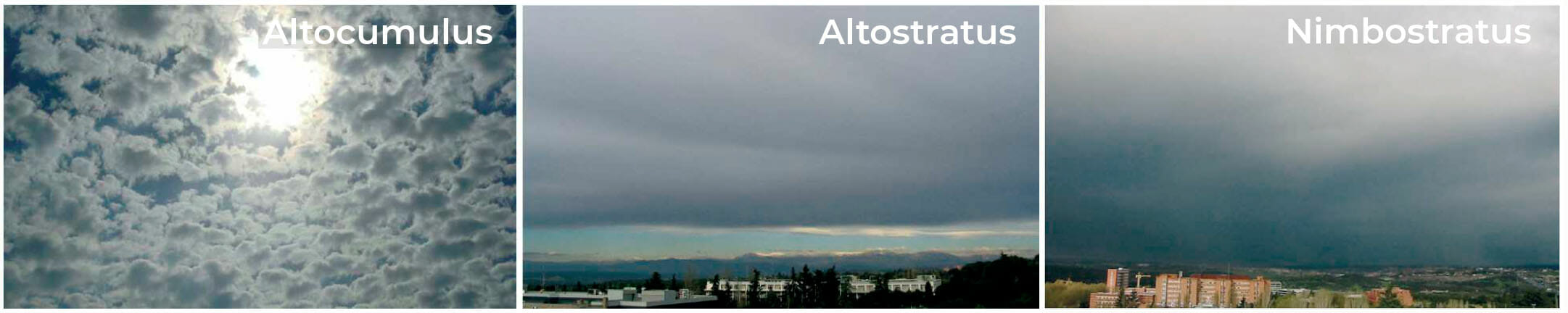
Mid-level clouds
These are clouds between 2,000 and 7,000 metres (at mid-latitudes) that consist of water droplets and, if the temperature is low enough, some ice crystals.
Altocumulus (Ac).
They are identifiable as a thin layer with shadows composed of rounded masses, which are sometimes partly fibrous or diffuse.
When they are isolated, they are indicative of good weather. If they increase in density or if they are mixed with altostratus, this indicates the proximity of a front or storm. They can cause precipitation.
Altostratus (As).
They are identifiable as a greyish or bluish cloud sheet, striated or fibrous, or uniform, covering all or part of the sky like a large sheet. It has thinner parts that let sunlight through, like a pane of glass.
They are associated with warm fronts and usually provide constant light rain or snow.
They are an indication to pilots of the proximity of a frontal system, and cause light icing on aircraft surfaces.
Nimbostratus (Ns).
They can be identified as a gray cloud layer, often dark, whose appearance is veiled by the rain or snow that falls more or less continuously from it. They are thick enough to completely block out the sun.
They are very thick mid-level clouds associated with frontal systems. They can cause icing if the temperature is low enough. They cause moderate turbulence at most, except at low levels and in mountainous areas, where it can be strong.
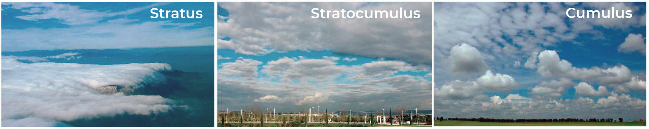
Low-level clouds
These clouds have bases below 2,000 metres and are almost always made up of water droplets; although in cold climates, they may also contain ice and snow particles.
Stratus (St).
Layer of generally grey clouds with a uniform base from which rain or ice crystals can fall. When the sun is visible through the layer, it can be clearly identified.
These are very low clouds, and thus of no importance at altitude, but when landing, they can pose a serious obstacle, since their base is below the minimum regulatory limits for landing. They do not cause turbulence or icing.
Stratocumulus (Sc).
They are identifiable as a bank, sheet or layer of grey or whitish clouds that have almost always dark clumps made up of rounded masses that may be joined or not.
They are associated with good weather in the summer when they appear mid-afternoon as a result of the evolution of cumulus clouds in good weather. They are not good indicators of a change in weather.
There is usually turbulence below stratocumulus clouds due to thermal changes. When flying above them, the air is usually very stable. Any icing will be very minor.
Cumulus (Cu).
These are detached, generally dense clouds with well-defined outlines, that develop vertically in the form of bumps, domes or towers, the convex tops of which often look like a cauliflower. The parts of these clouds are bright white when lit by the sun; their base is dark and horizontal. Sometimes they seem to be ripped apart by the wind.
Ideally, they should be avoided but if the plane must fly through them, it should do so at the maximum possible altitude.
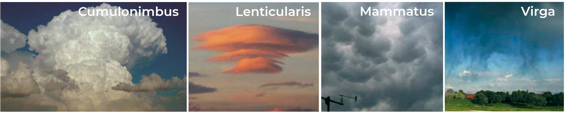
Other types of clouds
Cumulonimbus (Cb).
Dense, vertically developing cloud in the shape of a mountain or large towers. It has the characteristic anvil shape. Below the base, which is very dark, there are low clouds that have torn away, precipitation and rain, accompanied by gusty winds and lightning that travels between the clouds or to/from the ground.
They can be isolated with a width of 25 km, or in a line up to 500 km long. They should be avoided if at all possible by going around them if they are isolated, and crossed if they are in a line. These systems are associated with strong turbulence, hail, icing and lightning.
Altocumulus lenticularis
Formed by strong winds at high altitudes of 3 to 5 km, forming waves downwind, with several superimposed layers (lentils) remaining stationary.
Mammatus
Clouds resembling pouches that hang from the top of the anvil of a Cumulonimbus, although they sometimes form in Altostratus clouds. They are the result of a cool, humid mass that drops from the top of the cloud and meets warm air rising from below.
Virga
Sometimes water droplets, snow layers or ice crystals falling from a cloud evaporate before coming into contact with the ground, creating a visual effect in the shape of a curtain that hangs from the base of the cloud.
Contrails
Artificial clouds that are produced by the engines of planes flying at a high altitude, between 8-12 km. The engines emit water that freezes immediately if the humidity and temperature conditions are right. If the air layer is not sufficiently humid, contrails will not form.
Sea of clouds
We above the clouds, the sun reflecting off them makes it look like we are in a sea of clouds.
Pileus
Cloud in the shape of a hat or cap at the top of another cloud. They form when strong convective currents rise quickly in highly unstable weather, crossing through thin, humid and stable layers that are interspersed at the top of the troposphere.
In aviation, and especially in the field of air transport, it is very important to recognize clouds and to know the effect that each type may have on a flight. As a result, a knowledge of clouds is part of the basic training of any crew.
And for those who love to fly, there is no better way to pass the time from the window seat than to explore the different types of clouds we find along the way.