
Aircraft, whether manned or unmanned, constitute a growing sector worldwide. They form part of a scenario that is currently being configured so that it will soon become a daily part of our society. We are talking about the development of advanced air mobility and its coexistence with conventional air traffic.
One of the guarantees for Advanced Air Mobility (AAM) to be a success is having a common framework for regulatory and technological integration, such as U-space.
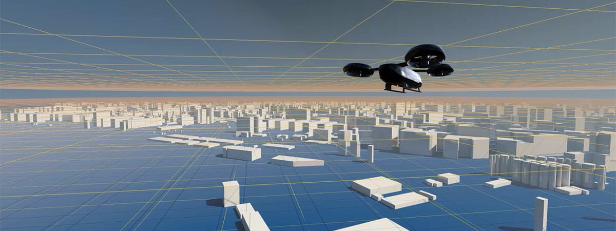
Not just small drones, but also larger UASs and VTOLs will provide services in all environments, including urban and peri-urban areas. Surveillance, infrastructure inspections, precision agriculture, parcel delivery, emergency services or transport of people are just some of the services that will coexist in a space that was not available to all of them until now.
If we had to define U-space in one sentence, it could be said that it is a regulation, management and operation environment that will integrate all types of aircraft so they can coexist and cooperate safely throughout our airspace, especially in urban environments.
The main purpose of U-space is to have a regulatory framework for air traffic, taking into account not only flights with manned aircraft, but also those carried out with UASs/drones from the different categories.
Ultimately, we are talking about a set of new services based on a high level of digitalisation and automation of specific functions and procedures, relating to both the performance of the air vehicles themselves, and their coexistence and control on the ground. These services will be designed to support safe, efficient and protected access to airspace for a high number of air vehicles from different categories. In this sense, U-space is a framework designed to facilitate all types of missions, in different classes of airspace and environments, under air traffic control parameters that guarantee operation and safety, both of the vehicles themselves, as well as the goods and people in the environment where they carry out their operation.
To ensure this, an entire regulated space structure has been proposed, which is expected to manage airspace operations, also creating segregated spaces with different levels of specific safety depending on the risk posed by the operation carried out with the aircraft, whether manned or not (safety of people, protection of the environment, health risks, etc.).
This environment will be responsible for regulating different actions related to aircraft operations, as well as for providing services to pilots or supervisors, ensuring a safe flight experience. From this perspective, U-space is also a digital tool that integrates air service providers, local authorities and security forces.
In addition, the creation of a clear framework at European Union level will allow the creation and promotion of a more dynamic market with very clear rules of the game. The most direct consequences of this will be the orderly development of a new economic sector and the creation of new jobs.
U-space is the name the European Union has given to this project to integrate unmanned aerial systems (UASs, drones, VTOLs, etc.) and other aircraft that share the airspace into a unified platform. This space will be regulated by local authorities to manage air traffic easily and safely.
And how did U-space come to be? Sesar Joint Undertaking is an institutionalised European partnership between public and private sector partners focused on research and innovation to facilitate the creation and implementation of the digital European sky. In this regard, in 2017, SESAR drafted a plan that would allow U-space to be operationally possible.
For a perfect development to achieve the ideal scenario proposed by the U-space concept, four progressive phases have been planned for the next ten years to automate processes. The implementation of the different phases is associated with the availability of services and technologies. The services will evolve, as will the level of automation of the drones.
We have been immersed in phase U1 since 2017, which includes the launch of the most basic services of the platform, such as:
- Electronic registration and identification system for pilots (and supervisors) and aircraft.
- Provision of basic information about pilots and registered aircraft.
- Provision of flight data for drone operators and pilots (flight zones, etc.).
- Geofencing, which is the definition of the geospatial perimeter around a zone or area that delimits access authorisation.
- Enabling new types of operations and expanding the scope of VLOS (Visual Line of Sight) operations or relaxing limitations on BVLOS (Beyond Visual Line of Sight)
Phase U2 is expected to start in 2023, and includes a series of services that will be very useful for supporting pilots. The gradual digitalisation of procedures will also allow an increase in the density of operations. The services that will be enabled in this phase will include:
- Geofence system with immediate effect (tactics).
- Digital flight planning system.
- Aircraft and flight tracking.
- Permit request and approval system for specific operations.
- Air traffic information.
- Meteorological information.
- Management of emergency situations.
- Information on emergencies in real time.
- Air conflict management.
- Support for incursions into controlled airspace.
- Airspace monitoring.
Phase U3 for the application of the U-space regulation includes the implementation of more complex and advanced services that will help to optimise air traffic with automated systems. It is about facilitating new and improved operations in areas of greater population density or that involve greater difficulty in the procedures. The services planned for this phase include:
- Dynamic geofencing.
- Obstacle detection and avoidance system.
- Automation of avoidance actions.
- Dynamic capacity management.
- Automated management of air conflicts.
- Active communication with airspace regulatory bodies.
- Collaborative interface with ATC.
Phase U4 will be the final implementation phase of the U-space regulation system and is scheduled for 2030. The process of integrating all services offered in the previous phases will be completed in this phase, advancing towards complete automation, connectivity and digitalisation. Additional services will be fully implemented in this phase:
- Automatic interconnection of all aircraft circulating in the airspace.
- Integration of pilots and flight supervisors with managers and regulatory authorities through digital channels.
- Integrated interfaces with ATM/ATC and manned aviation.
- Complete interaction of VFRs and UASs/Drones.
However, what services will U-space provide?
U-space will encompass different services, such as information provision, support in flight planning or aircraft tracking, among others. New services will also emerge as the concept develops.
For the provision of services, new types of suppliers will emerge, called CISPs and USSPs, which will be integrated into the current air traffic management (ATM) system.
The main purpose of Common Information Service Providers (CISPs) is to disseminate static and dynamic data that can serve as a basis for the provision of services in relation to the management of unmanned aircraft traffic. They are the single and reliable source of all common information in the U-space airspaces under their responsibility.. There can only be one certified CISP for each U-space airspace.
The provision of services within the U-space across all phases of operation will be managed by certified USSPs (U-Space Services Providers), and there may be several providers in each U-space volume. They must coordinate with the rest of the service providers, both from the U-space and from the airspace.
Going into the services that will be provided, there are several that are mandatory for any operation in the U-space and that, therefore, must be available in all cases. They are as follows:
Network identification service, through which airspace managers will be able to identify any aircraft throughout the duration of the flight and link it to the information stored in the log.
Geo-awareness service, aimed at having information regarding operational conditions, the relevant geographical areas for the flight, any airspace limitations applicable to each aircraft and existing restrictions (static or dynamic).
Authorisation service, which will provide operators with the authorisation (if applicable) for each individual flight, establishing its terms and conditions.
Air traffic information service, which will make it possible to find out about any other traffic close to the position or the planned flight route of the aircraft.
Apart from these services, which are considered mandatory, there are others that are optional, such as:
Meteorological information service, provided by trusted sources and at various scales (climate, regional and local), which will serve, both in terms of real-time information and forecasts, to maintain security and support the operational decisions of other services.
Compliance supervision service, which will allow operators to check if they meet the established requirements and the terms of the UAS flight authorisation.
In addition to these services, there will be others that will be added to each airspace, according to their availability and capacity.
From the current perspective, and especially if you are not familiar with the evolution of technology, regulations or innovations in the field of advanced air mobility, all of this may sound like science fiction. The truth is that a lot of progress has already been made (we are finishing the U1 phase without too much delay) and soon we will have an integration framework for aircraft in urban and peri-urban airspaces.
In Europe, where the regulations, work commissions and agreements between countries tend to be very slow, the development of the U-space concept is a very positive and promising example.
#uam #aam