Everyone understands the close relationship between meteorology and aeronautics. For an airport, having accurate, complete and up-to-date meteorological information is vital to its operations, given that operating procedures vary depending on the weather.
METAR is the name for the report that communicates meteorological information and the weather forecast, which are key elements for air traffic management.
For this reason, all airports have their own weather station, which provides ATC with information on existing weather conditions at the airport. From there, the information is distributed to the other airport stakeholders for whom it is relevant (mainly pilots and the Operations department). Pilots act according to this information, following the procedures established for this purpose, and the Operations department makes decisions on the runway configuration to be used.
The weather information is transmitted through a code known as METAR (METeorological Aerodrome Report), which consists of a series of letters and numbers that provide the information in an abbreviated and standardized form. These codes, whose origin dates back to 1968, began to be fully used in aviation at the end of the 1980s and are accepted internationally, although in North America they are used with slight differences.
The information contained in an international METAR code always takes the following order: Place – Date and Time – Wind – Visibility – Phenomena – Clouds – Temperature – Pressure. This ensures that it is easy to understand these codes once you have read a few:
Place
The ICAO code of the airport which has issued the report.
Date and Time
This consists of a six-number code followed by the letter Z. The first two indicate the date of the METAR code, while the next four indicate the time at which it was published. The letter “Z” indicates that the time is “Zulu”; that is to say, corresponding to the Greenwich Meridian, known as Coordinated Universal Time (UTC).
Wind
The METAR code provides the direction of the wind relative to true north, as well as the average wind speed expressed in knots.
After the code that gives the direction and the average speed of the wind, another may appear in the form XXXVYYY, which indicates that the wind direction varies between XXX and YYY.
Visibility
Indicates the horizontal visibility expressed in metres. A visibility greater than 10 km is indicated by 9999. If the visibility is less than 2000 m, the existing RVR should be indicated.
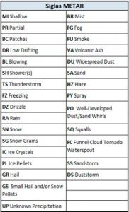
The existence or non-existence of significant weather phenomena are indicated with the following acronyms (see table):
Clouds
The METAR code indicates the cloud cover expressed in ‘oktas’ of sky occupied by cloud, and indicating the height of the cloud ceiling. To this end, the sky over the airport is divided into eight sections and, depending on how many eighths of sky are covered, the following information is given:
FEW – 1 to 2 oktas of cloud cover.
SCT (Scattered) – 3 to 4 oktas of cloud cover.
BKN (Broken) – 5 to 7 oktas of cloud cover.
OVC (Overcast) – 8 oktas of cloud cover (completely overcast).
The height of the cloud layer (cloud ceiling) is shown in hundreds of feet (ft), just as flight altitude is measured.
If there are no clouds or significant weather phenomena and if visibility is at 10 km or greater, the acronym CAVOK (Ceiling and Visibility OK) is used.
Temperature
This consists of a four-number code. The first two numbers indicate the temperature at the airport, and the remaining two indicate dew point temperature, both expressed in degrees Celsius.
Pressure
This consists of a Q followed by a number (usually four digits) that indicates the airport’s existing QNH, that is to say, the pressure at sea level deduced from the pressure existing at the airport, expressed in hectopascals.
Lastly, if the key “NOSIG” appears after the METAR, this indicates that no significant changes in weather conditions are expected in the two hours following the publication of the METAR.
As the proof of the pudding is in the eating, we offer a couple of examples to better understand how the METAR code works:
LEMG 280800Z 30002KT CAVOK 13/09 Q1020 NOSIG
Location: Malaga Airport (LEMG)
Day: 28
Time: 08:00 UTC
Wind direction and speed: 300º and 2 kt
Clouds and visibility: CAVOK conditions (no clouds or weather phenomena and visibility of more than 10 km)
Temperature: 13º
Dew point temperature: 9º
Pressure: 1020 hPa
No significant changes for the next two hours.
EGLL 251720Z 35004KT 320V020 9999 BKN042 OVC049 11/04 Q1013
Location: London-Heathrow Airport (EGLL)
Day: 25
Time: 17:20 UTC
Wind direction and speed: 350º and 4 kt
Wind variable between 320º and 20º with respect to Geographic North
Visibility: greater than 10 km
Clouds: sky practically covered (“Broken”) at 4200 ft and fully covered (“OVC”) at 4900 ft
Temperature: 11º
Dew point temperature: 4º
Pressure: 1013 hPa
To put all this into practice, I invite the reader to decode the following METAR codes:
LEMD 270530Z 11004KT 9999 FEW050 05/02 Q1025 NOSIG
GCXO 280500Z 18004KT 150V230 5000 HZ 17/07 Q1019 NOSIG
EHAM 271825Z 13008KT 9000 -RADZ FEW008 SCT010 BKN012 07/06 Q1005
(Tip: if this seems too complicated, there are pages such as Metar Reader that serve to decode any METAR).


