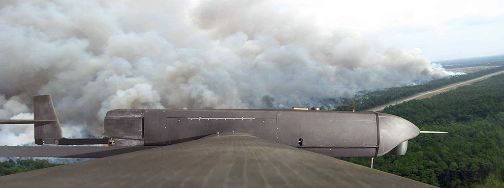
Remotely piloted aircraft systems (commonly known as RPAS or UAV) are tools that are currently in the assessment and testing stage to provide support to the extinction of forest fires.
Due to their characteristics and the environments where they are employed, they will end up becoming as essential and indispensable as Communications and Observation Aircraft (COA) have been for years. This is the case because they offer perfect integration with complex fighting operations and the fact that they have demonstrated the inestimable help they provide.
But let’s go back to basics…
A forest fire is a race against time in which the fire competes against humans. The former moves and grows while it can find combustible materials to feed itself and the latter do whatever they can to deny it those combustible materials while at the same time making it smaller.
RPAS’s most useful task in a fire currently consists of ongoing surveillance, which minimises risks to people.
The fire advances as long as there is nothing to impede it. It does so by following the paths and areas where it can propagate itself better, which are defined by the prevailing wind at the time, which in turn is superimposed on the distribution of combustible plant materials and the terrain’s relief. These two elements together shape the way it advances. All these factors together make the fire behave in a way that is not always predictable, and even erratically so at times.
It is therefore essential to keep a fire under ongoing surveillance to know its evolution and exact geographic location in real time. Knowing these two parameters allows one to place fire extinction resources at the best locations to attack the fire, thereby increasing their effectiveness while at the same time reducing as much as possible the high risks they run.
However, something curious happens in this race against time. From dawn to dusk (during the day), humans fight ceaselessly without losing sight of nature and its surroundings to plan their next move and to stay one step ahead of it. From dusk to dawn (at night) though, aerial observation resources are obliged to withdraw due to the enormous dangers to which their crews are exposed. Thus, humans suddenly find themselves with one hand tied behind their backs (or better said, blind) in this race while the fire carries on at its own pace and continues to change direction, size and virulence as the conditions which surround it vary.
At night, control over the fire is greatly reduced in terms of knowledge/intelligence, while it continues advancing, changing, expanding and contracting.
To all this we must add the fact that fighting against the fire is more efficient at night, since the ambient temperature is lower and wind speeds usually fall. Therefore, any actions done at night or first thing in the morning tend to be more effective than at midday.
Fortunately, RPAS technology is now highly advanced. One of its key features is that it eliminates the human risk factor involved in operations, as there are no pilots in the aircraft. In other words, using RPAS is particularly suitable in any operations involving high risks to pilots, because their crews are always safe and sound on the ground, far from the aircraft. RPAS are therefore very suited to conduct monitoring and observation tasks by flying above fires at night.
This activity is most effective when it is carried out by long-range RPAS having extended autonomy. This type of RPAS tends to be comprised of fixed-wing RPAS (in other words, which look like a traditional aircraft), because their configuration allows them to fly above the fire all night long (with flight times of six, eight or more hours). They are stable, easy to operate, have a long range and can carry very powerful cameras. In their support configuration, they are not designed to attack the fire with fire retardants or water, but solely to observe and monitor the fire from the air (RPAS capable of attacking fires are also under development, but will take somewhat more to develop than observation RPAS due to the fact that they are far more complex).
Helicopter-like RPAS (rotary-wing RPAS) are used on a complementary basis because they do not need runways to operate, since they have vertical take-off and landing capabilities. Lastly, electric multicopters are used for specific, nearby, short-range operations to provide rapid support.
Each of the tools mentioned above (aeroplanes, helicopters and multicopters) have their own advantages and disadvantages. In general, however, all them are mutually compatible. Thus, the success and efficient use of RPAS basically consist of realistically defining the outcome and the operation that is to be carried out.
For the moment, the following operating options (or combinations thereof) are available depending on the RPAS employed and its usual coverage and availability:
- Total proactive range (Flying above the fire all night. Should ideally be requested before night falls): Fixed-wing RPAS
- Medium semi-reactive range (Part of the night and/or part of the fire. May be requested during the night): RPAS helicopters
- Short reactive range (Area near the operator, from half an hour to an hour away. May be requested at any time during the night): RPAS multicopters
If the operation has been defined well, then the choice of one of these tools or combination thereof is immediate and will provide tremendously useful data.
In any event, as the main characteristic feature of RPAS, they should carry two kinds of cameras: a high-sensitivity visible spectrum camera and an infrared spectrum camera. They should also be equipped with the capability to transmit real-time images in a georeferenced format, so that the signals’ recipient, usually the Advanced Command Post (ACP), can relate or automatically view said images or fragments thereof directly on the area’s map.
Fire extinction services work with Geographic Information Systems (GIS), which are georeferenced databases where all the direct and indirect parameters related to a fire appear. They are comprised of layers of information whose most evident form of display are maps, where one can select the information to be analysed at any given time and where the data obtained by the RPAS is of significant value for analysis and decision-making purposes.
GIS allow different maps to be overlaid and combined. In the case of the forest fires, for instance, they allow one to overlay relief maps onto maps of combustible natural materials. Hence, when weather forecasts are added, they can provide outstanding technical information on a fire’s potential evolution.
However, reality has shown us that fires do not always evolve as predicted. Sometimes they even seem capricious. If we take into consideration the fact that changing weather conditions affect the fire and the fire in turn exerts an influence on its micro‑environment’s conditions, we find ourselves with scenarios that rarely follow theoretical ideas. That is why it is always of immense help to be able to rely on having eyes on the ground on an ongoing basis, during the day and at night.


