It was 22:00 on an August night. A wave of high temperatures was crossing the whole of South of Europe from east to west, exacerbated by the strong easterly winds that are common in the summer months. At night, temperatures did not fall below 30 °C, and during the day the heat was overwhelming, as temperatures reached and surpassed 40 ºC.
The two operators of the fixed-wing Remotely Piloted Aircraft System (RPAS) (commonly known as drones) and the operations coordinator were feeling a little cramped in the van.
During the forest fire season, all the material equipment is always perfectly prepared and ready to leave as soon as there is an alarm.
Put simply, the equipment consisted of an unmanned dismountable aircraft with a sophisticated autonomous navigation system, supervised and operated remotely by an operator on the ground. In addition, it transmits real-time images captured with a high definition optical spectrum camera, and a second coaxial infrared spectrum camera of 680 x 480 pixels.
As we were in the middle of the forest fire season, and we had already received an early warning, we knew that it was highly probably that this moment would occur on this exact night. During the forest fire season, all the material equipment is always perfectly prepared and ready to leave as soon as an alarm is raised. However, the procedure still requires everything to be reviewed just before you leave, following a checklist. That is when you start to feel nervous.
That night, firefighters had just confirmed that the fire they had been warning us about since the morning could not be controlled, and it was spreading towards urban centres. We were therefore needed on the site urgently.
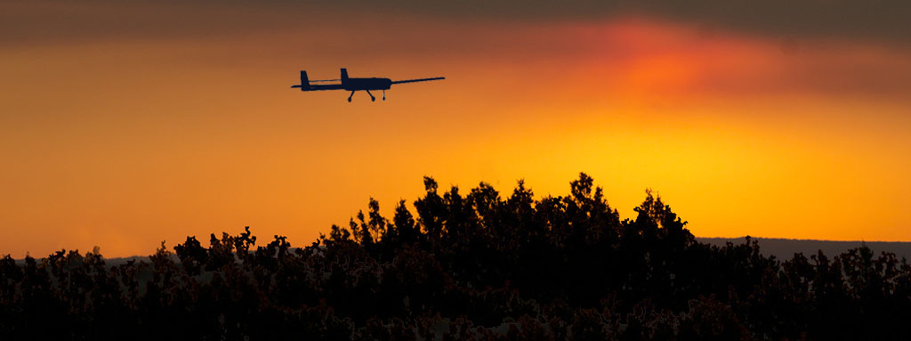
Our mission was to operate a fixed-wing RPAS flying over the fire during the night, in order to support the fire extinction work and provide direct on-going information.
As we got closer, now just a few kilometres away from the fire zone, we began to notice the smell of burning undergrowth and see the glow of flames reflected in the clouds of smoke they were producing.
The first sign of unusual activity in the area became obvious when we saw the flashing blue lights on the vehicles of the Guardia Civil (Spanish military police), in charge of diverting traffic towards safe areas. We identified ourselves, and they let us pass along the road that led directly to the windward front of the fire. The first few times you voluntarily approach a fire, the feature you find most striking is the uncontrolled violence you are facing. At night, the intense brightness of the flames, visible from afar, gives you a clear idea of its sheer scale and the rapidity of its advance.
We reached the Advanced Command Post (Puesto de Mando Avanzado, PMA) or Mobile Meteorology and Transmission Unit (Unidad Móvil de Meteorología y Transmisiones, UMMT), which is essentially a sophisticated off-road truck where all communications and intelligence gathered about the emergency are centralised in order to coordinate the response. Once there, we registered with those in command and we confirmed the communication links and protocols already rehearsed during the year. The atmosphere around the PMA was frantic and urgent. Firefighters arrived bringing the latest news from the front, and returned with new instructions according to the most recent changes received and analysed.
They confirmed our authorisation and registration for the flight, and we therefore returned to our operating base, which was close by, in a designated safe area. From there, we proceeded to immediately deploy the equipment and fine-tune it for the start of the operation.
The unmanned aircraft system was ready. The pre-flight list had been checked through, and all warning lights and alarms were green. The cameras were transmitting properly and reception was good. Authorisation to begin the flight was once again requested from the PMA via walkie-talkie. As soon as we received authorisation, the operator entered the confirmation code and the aircraft initiated its take-off alone, and headed off to fly over the fire. As it was the middle of the night, we lost sight of the aircraft when it was just a few metres away, and we were left with only its position lights and anti-collision strobe lights visible. However, the RPAS continued to do its job, sending images while flying automatically under the supervision of the operator installed among computer monitors in the back of the van.
From that moment, the PMA could already begin to receive images captured by the infrared cameras and the high-sensitivity electro-optics, along with geographical referencing data captured by the drone, which allowed each image showing the fire’s leading edge to be placed on a map.
Until that point, the information about the fire’s leading edge obtained during the day had not been available at night. Now, decision-making during the night is easier, safer and more effective, due to having this valuable information. Thanks to these tools, humans can now “run” at night too in their race against the fire.
Information in the form of images and geographical references received directly from the drone is processed by firefighting experts in their posts in the PMA. With real-time observation of the evolution of the fire they can fine-tune the distribution of human and material resources with great accuracy and target strategic points of maximum effectiveness, in order to continue working at night and in the early hours of the following morning.
This story may seem fictitious or fantastic to you, but it is not – it is an account of what occurred recently during a huge level 2 fire in southern Spain.